
A song for you: The Lost Words Blessing
P.S. And if you like that one, listen to: Thrift (Dig In, Dig In)
P.P.S. With many thanks to the Spell Songs ensemble, Robert Macfarlane, Jackie Morris, and everyone else who made these recordings possible!
A song for you: The Lost Words Blessing
P.S. And if you like that one, listen to: Thrift (Dig In, Dig In)
P.P.S. With many thanks to the Spell Songs ensemble, Robert Macfarlane, Jackie Morris, and everyone else who made these recordings possible!

Back in December, I was trying to photograph this fish in the low intertidal zone:


This one is from earlier in January. I like the way the rainbow colors appear along the different sections of the wave.
Sometimes it's hard to choose...three views of the western horizon after sunset on 21 January 2022:


Black Oystercatcher (Haematopus bachmani) and California Mussels (Mytilus californianus). Photographed at sunset on 17 January 2022.
To document evidence of the tsunami yesterday, I took a few photos from the shoreline of Bodega Harbor. Below I'll share a short time series, but before I do that I wanted to explain what you'll be seeing.
I learned a lot from seeing the Tohoku tsunami in 2011. It's easier to think about these effects not as one larger wave, but instead as a series of water level changes. The water surges above the predicted tide height and then recedes below the predicted tide height, and this happens over and over and over again. (In 2011 the effects were visible for at least 7 days.) These changes in water level happen relatively quickly – e.g., rather than taking 6 hours to go from high tide to low tide, during the tsunami events we've experienced in 2011 and 2022 some of the water levels changed from the equivalent of high tide to low tide within 30 minutes!
So if the estimate for the Bodega Bay area was for the water level to change by 1.5 feet, then the water level would surge 1.5 feet above the predicted tide height and then recede 1.5 feet below the predicted tide height, and then the flow direction would change and the water would come in again and then go out again. (In general, the water level deviations are greatest within the first day and then get smaller during the following days.)
Because waves in this area are large (often in the 5-8 foot range), it's actually harder to see the effects of a 1.5 foot water level change on the outer coast. (Although there can be dangerous surges on sandy beaches.) But the effects of the tsunami are much easier to see in Bodega Harbor during low tides because you can see the water flooding over the tidal flats and then receding and then flooding in again. I'll admit, after spending most of my life around tides, it has felt somewhat surreal to me to see this happening!
So here's a time series of photos taken from the same site along Westshore Road. There is a pink arrow pointing to a clump of algae for a visual landmark to judge the height of the water. (Note that in these images the water flows in from the left and then recedes to the left.)
The first image was taken at 1:02 p.m. when the water level was relatively high:

Then the water receded and was very low within 15 minutes, the time of the second image at 1:17 p.m.:

Then suddenly the water started surging back in and it returned to the relatively high level within 7 minutes, by 1:24 p.m.:

After that the water receded again and stayed out for while (but it eventually came back in ~2:30 p.m. after I had left):


Amazing to see the effects of the Tonga tsunami reaching Bodega Bay, ~5200 miles (8500 km) away.
P.S. You can click on the images above and then move through the images faster to see the water level receding, flooding, and receding again.


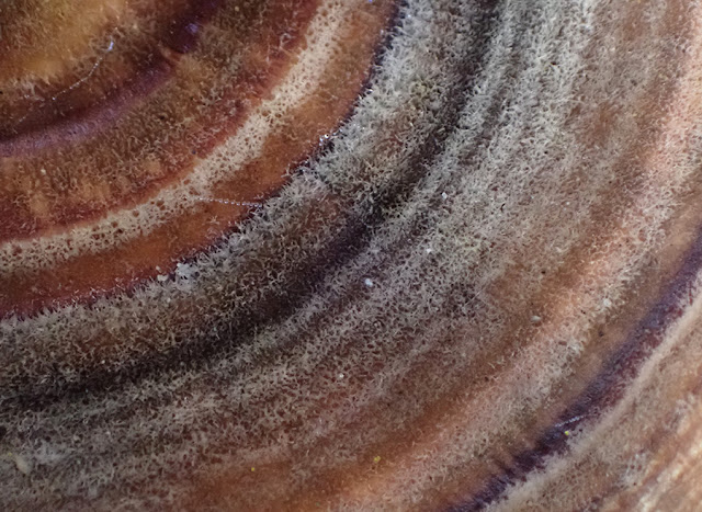
So cool to zoom in on these beautiful colors in a shelf fungus in our backyard! (And what an amazing sweater pattern this would make!)
Here's a close-up:


This sculpin's orange coloration was a perfect match with the nearby sponge (visible in the foreground)! Photographed in the low intertidal zone on 3 January 2022.

Early morning light on a Northern Harrier (Circus hudsonius). I helped out with the Western Sonoma County Christmas Bird Count today (2 January 2022). It was a chilly start to the day (patches of frost on Bodega Head) and this harrier's feathers were puffed up a bit. A down jacket was a good idea this morning!

A nice Cabezon (Scorpaenichthys marmoratus) photographed by Eric back in early December.


